
What do you do if you’re a scientist carrying out fieldwork in forests, far from routes you can find on Google Maps? On a quiet and cold evening inside the Core zone of Corbett National Park, our vehicle jerking along some unfamiliar path, I was nervous and tense when our driver said, “Sir ji! lagta hai galat rasta pakad liya humne..!” He said he thought we were on the wrong route, and I had a camera trap to retrieve, so those words from my driver were the last thing I was hoping to hear.
As Sonu struggled to hit the right track, I tried piecing together every detail I could gather, hoping to find the way. After close to 20 minutes of futile driving and brain racking, I remembered that I had mapped the entire route leading to the deployed camera traps in Locus Map, a popular GPS-based mapping app that many researchers use for situations like this one. It took us another 15 minutes to take a detour and finally reach the desired location. I took off the camera trap and climbed back into the vehicle. Going through the photographs, I could not decide what brought more relief and happiness to me at that moment, the beautifully captured images of tigers in the camera, or the Locus Map in my phone still wide open on my screen.
As researchers we commonly use this app for marking important locations like that of camera trap deployments, animal den sites, a river source, or in more general, a particular remote village site. I came across this app two years back while working on the ecology of Indian Grey Wolf as a Project Associate with Tiger Watch. My objective was to assess the habitat use of Indian-grey wolf inside the Kailadevi Wildlife Sanctuary (KWS). I used a software called ArcGIS to lay grids of 4×4 sq. km each on the whole study area spanning 684 sq. km, but the handheld GPS did not allow all the grids to be visible at the same time. A fellow researcher, a field biologist working in the Ranthambhore Tiger Reserve came to my rescue,

The interface of Locus Map
Photo Credit: Screenshots by Prashant Mahajan
“Suno, tum Locus Map download karo. Ye baaki jhanjhat mein mat pado.” (Just download Locus Map). “It uses a phone’s GPS to detect one’s current location. It has a vast repository of maps from all over the world, and the best thing about it, it works even without an Internet connection. You install it, and see for yourself,” he said.
Within no time I was well versed with the application. I imported my grid file to the app, and there they were, all 48 grids visible at the same time, just as I had wanted. Although looking at 48 grids together now seemed easy, walking through each of them to collect data on wolf’s direct and indirect signs, while also recording the total walked track, marking the important locations on the way seemed a daunting task to me. So, I approached some wildlife volunteers from the KWS villages working with Tiger Watch. I passed on my new found knowledge of Locus Map to the volunteers and trained them on its proper use without making it confusing for them. I marked some locations as landmarks to make it easier for them to locate the starting point of the grid.
At 5 grids per day, traversing 10-12 kms in each grid, we were able to cover all the grids in the next ten days. The data was safely stored in the app and yielded some amazing results. We were able to document and mark signs of wolves, hyenas, foxes, chinkara, nilgai, golden jackals, hares, bears, leopards and even few signs of tiger.
Trekking in remote forests for data collection on animal locations can be quite challenging and I have often had difficulty remembering the route taken after several kilometres of walking. In times like these, technologies like GPS, Locus Map etc. provide the much-needed aid, although conventional handheld GPS navigation devices are not much user-friendly and do not provide comprehensive maps unlike the latter which does it enabling one to ‘know’ the upcoming terrain, how the route looks like, its length, elevation profile etc. Every now and then, I click pictures using it and geotag them easily for future reference.
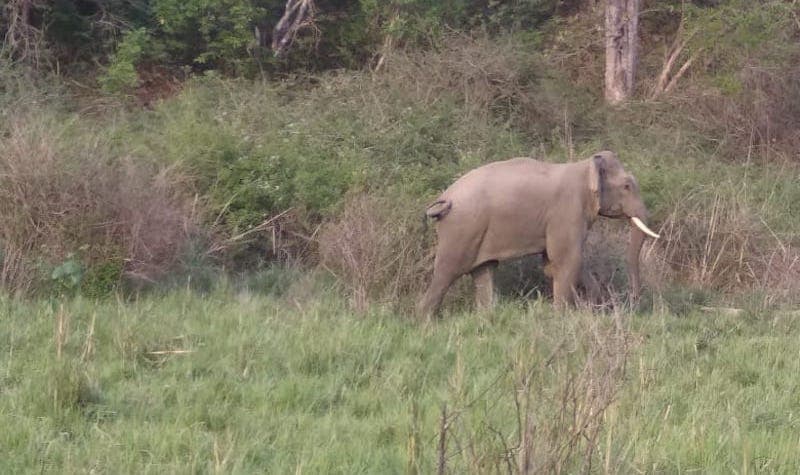
A male tusker at Corbett National Park
Photo Credit: Prashant Mahajan
To limit the relevance of Locus Map to the world of wildlife research would be a felony on my part, as I have actively used it on leisure hiking and trekking trips too. On one such occasion, I recommended it to one of my friends. The user-friendliness of the app has made it a favourite with her. For someone who is bad at remembering directions, a little knowledge of life-saving technologies like these has done her no harm.
A life without technology in the present world would perhaps be unimaginable. But to let it take control over our lives might not be the wisest option, especially during forest explorations. Once during data collection on elephant dung, I had my eyes glued to the mobile screen to record data continuously and for a moment forgot I was in a forest. Walking along the transect line I suddenly encountered a herd of elephants passing through the transect. Anyone who has experienced a herd of thumping beasts chasing them in an unknown forest wouldn’t mind throwing their phone to save their life!
Prashant Mahajan holds a Master’s degree in Wildlife Sciences from Aligarh Muslim University, besides being a graduate in Zoology from the Delhi University, and a writer. He has worked on the ecology of wolves in Rajasthan and was a part of the research team of the “All India Tiger Monitoring” project with Wildlife Institute of India. Currently he is a Project Fellow at Wildlife Institute of India.
Juno Negi is a researcher and blogger who completed her post-graduation in Anthropology with a bachelor’s degree in Zoology, from the University of Delhi. Currently working as a Junior Research Fellow at the Wildlife Institute of India.
This series is an initiative by the Nature Conservation Foundation, under their programme Nature Communication to encourage nature content in all Indian languages. If you’re interested in writing on nature and birds, please fill up this form.
How to find the best deals during online sales? We discussed this on Orbital, our weekly technology podcast, which you can subscribe to via Apple Podcasts, Google Podcasts, or RSS, download the episode, or just hit the play button below.